Log in
All resources
Create a design
5,084 Free Artworks of Pages With Maps
maps from the earth and its inhabitants, vol. iv
géographie générale; physique, politique et économique (1876)
the cruise of the marchesa (1889)
maps from the earth and its inhabitants, vol. xvii
maps from the earth and its inhabitants, vol. vii
maps from the earth and its inhabitants, vol. xiii
national library of poland
maps from the earth and its inhabitants, vol. xviii
maps from the earth and its inhabitants, vol. xi
gartenlaube (1888)
gartenlaube (1888)
emanuel spitzer
richard wane
port erin
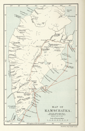
siberia and the exile system (1891)
19th-century maps of siberia
siberia and the exile system (1891)
19th-century maps of siberia
corona and coronet (1898)
travel maps of the world
map modeling in geography (1894)
ghosts & ghoulish scenes
maps by willem and johannes blaeu
german renaissance,northern renaissance
prints in the british museum
gartenlaube (1888)
emanuel spitzer
christmas and winter scenes from the british library mechanical curator collection
christmas in norway
a picturesque tour along the river ganges and jumna in india (1824)
s. j. neele & son
maps of pangong tso
old maps of ladakh
giovanni battista rossi
1890s maps of yemen
atlas ou representation du monde universel t. 1 (1633)
1630s maps of the netherlands
final report of the northwest territory celebration commission
maps by willem and johannes blaeu
in the volcanic eifel. a holiday ramble (1896)
old maps of eifel
maps in the staats- und universitätsbibliothek hamburg
latin-language book pages
the cruise of the marchesa (1889)
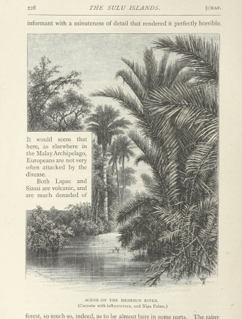
meimbun river
maps in the rijksmuseum amsterdam
johannes leupenius
the cruise of the marchesa (1889)
kamchatka oblast
nouvelle géographie universelle, vol. viii
1876 maps of india
maps in the library of congress
1708 maps
1880s maps of taiwan
1889 in taiwan
maps from the earth and its inhabitants, vol. iv
brentford, england
maps from the earth and its inhabitants, vol. xiv
maps of the southern ocean
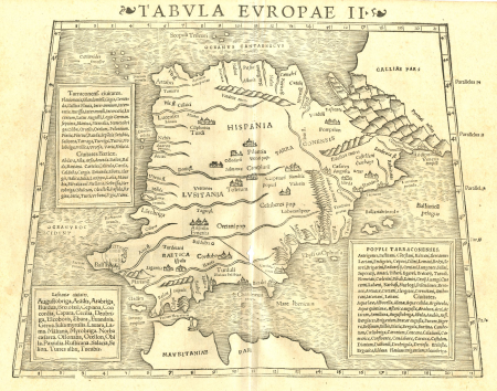
geographia universalis (1545) in the british museum
german renaissance,northern renaissance
maps from the earth and its inhabitants, vol. xvii
history of florida
old maps of the sinai peninsula
1840s maps of arabia
maps from the earth and its inhabitants, vol. xviii
colonialism
tian shan
alps
maps from the earth and its inhabitants, vol. iii
mining in austria
maps from the earth and its inhabitants, vol. x
maps with nicolosi globular projection
frankfurt (oder) city bridge before 1819
oder river in frankfurt (oder)
australia (1873) by booth
1870s maps of australia
20th-century maps of libya
giuseppe haimann
1890s maps of the caribbean
brethren of the coast
géographie générale; physique, politique et économique (1876)
19th-century maps of bretagne
géographie générale; physique, politique et économique (1876)
old maps of the strait of gibraltar
the cruise of the marchesa (1889)
maps of sumbawa
the cruise of the marchesa (1889)
old maps of kamchatka
arnold's geographical handbook (1899)
1899 maps of the caribbean
nypl collection of atlases, gazetteers, guidebooks and other books
nypl lionel pincus and princess firyal map division
john rocque's 1746 map of london
old and new london (book)
arnold's geographical handbook (1899)
1899 maps of india
nuevo atlas o teatro mundo
old maps of the arctic
illustrations de histoire naturelle - tome i - de seve 1749
maps of afro-eurasia
maps from the earth and its inhabitants, vol. iv
1870s maps of london
lawrence h. slaughter collection of english maps, charts, globes, books and atlases
nypl lionel pincus and princess firyal map division
maps of assen
paterswolde
patrimonium 2 (project)
realism
maps by hendrik hondius the younger
1631 maps
atlas ou representation du monde universel t. 1 (1633)
17th-century double hemisphere world maps
our arctic province, alaska and the seal islands (1886)
old maps of alaska
illustrations de histoire naturelle - tome i - de seve 1749
1740s maps of the americas
maps from the earth and its inhabitants, vol. iv
maps of cheltenham
maps from the earth and its inhabitants, vol. iv
19th-century double hemisphere world maps
maps of rivers of south sudan
sobat river
maps from the earth and its inhabitants, vol. xi
maps indicating exploration
maps from the earth and its inhabitants, vol. vii
19th-century maps of korea
maps from the earth and its inhabitants, vol. iv
portskewett
maps from the earth and its inhabitants, vol. iv
cirencester
maps from the earth and its inhabitants, vol. xiii
old maps of luanda
maps from the earth and its inhabitants, vol. iv
eddystone rocks, devon
maps from the earth and its inhabitants, vol. vi
topographic maps of asia
maps from the earth and its inhabitants, vol. vii
linguistic maps of chinese languages
maps from the earth and its inhabitants, vol. xi
roads in tunisia
maps from the earth and its inhabitants, vol. iii
maps of the sava watercourse system
maps from the earth and its inhabitants, vol. iv
queensferry crossing
maps from the earth and its inhabitants, vol. xvii
old maps of washington, d.c.
maps from the earth and its inhabitants, vol. xvi
ethnographic maps of north america
maps from the earth and its inhabitants, vol. v
ringkjøbing
maps from the earth and its inhabitants, vol. vii
charles eugène perron
maps from the earth and its inhabitants, vol. xviii
south america in the 19th century
maps from the earth and its inhabitants, vol. iv
snaith
maps from the earth and its inhabitants, vol. xvii
linguistic maps of north america
géographie générale; physique, politique et économique (1876)
1876 maps of germany
géographie générale; physique, politique et économique (1876)
1876 maps of germany
old maps of finnmark
1890s maps of norway
géographie générale; physique, politique et économique (1876)
1870s maps of liguria
géographie générale; physique, politique et économique (1876)
1876 maps of india
ismailïa. a narrative of the expedition to central africa for the suppression of the slave trade (1874)
nyanza, rwanda
maps from the earth and its inhabitants, vol. iv
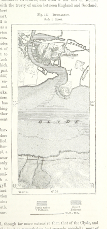
maps of dumbartonshire
maps from the earth and its inhabitants, vol. iv
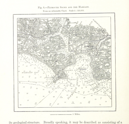
charts of plymouth sound
maps from the earth and its inhabitants, vol. iv
peterborough
maps from the earth and its inhabitants, vol. iv
19th-century maps of derbyshire
rivers of the western cape
maps of the western cape
1870s maps of venezuela
1878 in venezuela
maps from the earth and its inhabitants, vol. xi
oases of libya
maps from the earth and its inhabitants, vol. xvii
linguistic maps of north america
maps from the earth and its inhabitants, vol. vii
provinces of japan
maps of the districts of the canton of bern
biel/bienne (administrative district)
maps from the earth and its inhabitants, vol. v
maps of the north atlantic
maps from the earth and its inhabitants, vol. xvi
19th-century maps of mexico city
maps from the earth and its inhabitants, vol. xiii
maps of journeys
mining in south africa
maps of vaal river
maps from the earth and its inhabitants, vol. iv
lowestoft
maps from the earth and its inhabitants, vol. iv
milford haven
maps from the earth and its inhabitants, vol. iv
huddersfield
maps from the earth and its inhabitants, vol. xiv
exploration of australia
601 - 700 of 5,084
Next page
/ 51


![Gerardi Mercatoris and I. Hondii Atlas or Representation of the Universal World, and of the Parts of It, Made in Tables and Descriptions Very Ample, and Exact: Divided into Two Volumes [...]. [t. 1].](https://cdn.creazilla.com/illustrations/10000205839/gerardi-mercatoris-and-i-hondii-atlas-or-representation-of-the-universal-world-and-of-the-parts-of-it-made-in-tables-and-descriptions-very-ample-and-exact-divided-into-two-volumes-t-1-sm.webp)


![Gerardi Mercatoris and I. Hondii Atlas or Representation of the Universal World, and of the Parts of It, Made in Tables and Descriptions Very Ample, and Exact: Divided into Two Volumes [...]. [t. 1].](https://cdn.creazilla.com/illustrations/10000622971/gerardi-mercatoris-and-i-hondii-atlas-or-representation-of-the-universal-world-and-of-the-parts-of-it-made-in-tables-and-descriptions-very-ample-and-exact-divided-into-two-volumes-t-1-md.jpg)